Taal Volcano: Exploring the Philippines’ Lake Within a Volcano
Discover the complex geology, dramatic history, and breathtaking beauty of Taal Volcano south of Manila—a unique volcano within a lake on an island.
Taal Volcano: One of Asia’s Most Extraordinary Volcanoes
n
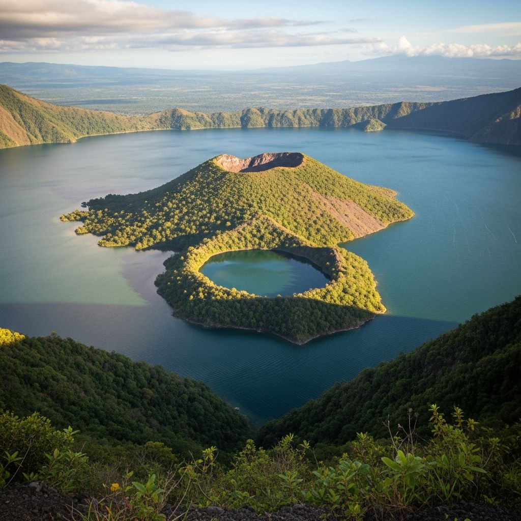
Visible from the cool ridge town of Tagaytay and just a short trip from Manila, Taal Volcano is a geological wonder that has captivated travelers, scientists, and locals alike for centuries. Unlike any other volcano in the Philippines, Taal sits uniquely as an island in the middle of Taal Lake, which itself occupies a vast, ancient caldera. Inside the volcano’s crater is yet another lake, producing a rare ‘volcano within a lake on an island within a lake.’ Its beauty disguises an active—and at times deadly—natural force.
nn
Where Is Taal Volcano? Understanding Its Unique Location
n
Taal Volcano is located in the province of Batangas on the island of Luzon, about 50 kilometers (31 miles) south of Metro Manila. Set at the heart of Taal Lake, it’s most easily viewed and accessed from the ridgeline city of Tagaytay, which provides panoramic vistas over the emerald-green water and volcanic island below.
nn
- n
- Nearest city: Tagaytay (about 20 minutes to the lake shore)
- Distance from Manila: 1.5 hours by car on average
- Lake size: Around 267 square kilometers (103 sq. mi.)
- Volcano elevation: 311 meters (1,020 feet)
n
n
n
n
nn
Visitors coming for the view usually stay in Tagaytay, where restaurants, hotels, and view decks overlook the volcano’s dramatic silhouette rising from the lake’s placid waters.
nn
The Geology and History of Taal Volcano
n
Taal Volcano’s structure is the culmination of massive prehistoric eruptions that shaped not only the volcano but also the surrounding region. Its central feature is a submerged caldera—an ancient volcanic crater now filled by Taal Lake. The present-day volcanic island, often simply called ‘Volcano Island,’ hosts the volcano’s most active cones and craters.
nn
Distinctive Geological Features
n
- n
- Volcano Island: The main island within Taal Lake, home to the active crater and several smaller craters and maars (explosion craters).
- Main Crater Lake: A lake that fills the volcano’s largest crater at the island’s summit; this is the lake visible from most viewpoints.
- Caldera: Taal Lake itself, a giant basin formed from prehistoric eruptions between 140,000 and 5,380 years ago.
- Multiple craters: Volcano Island actually has at least 47 distinct craters and 4 maars, making it one of the world’s most complex volcanic systems.
n
n
n
n
nn
A Chronology of Major Eruptions
n
Taal is the Philippines’ second most active volcano, with over 38 eruptions recorded since the late 16th century. Most historical eruptions have been violent, causing devastation and loss of life around the lake and its shore towns.
nn
| Date | Event and Impact |
|---|---|
| 1749–1754 | Series of violent eruptions, culminating in the catastrophic May-December 1754 event that buried villages and forced major town relocations. |
| 1911 | Explosive eruption destroyed the island’s landscape; ashfall reached Manila, deaths estimated near 1,300. |
| 1965 | Renewed activity at Mount Tabaro; resulted in fatalities, property loss, and reshaped the island. |
| 2020 | Large eruption sent ash over Luzon, disrupting airports, evacuating towns, and causing regional emergencies. |
| 2024 | Latest phreatic (steam-driven) activity; ongoing high alert for residents and visitors. |
nn
The combination of Taal’s proximity to populous areas and its unpredictable eruptive history is why it is designated a Decade Volcano—a site of particular importance for volcanologists and disaster planning.
nn
Scenic Wonders: What Makes Taal Volcano Unique
n
The views over Taal Volcano and its lake are among the most photogenic in all of the Philippines, attracting hikers, day-trippers, and nature fans year-round. What sets Taal apart from other volcanoes are its:
nn
- n
- Volcano-inside-a-lake-inside-an-island-inside-a-lake motif: A globally rare topographical setup.
- Crater Lake’s vibrant colors: Varying from turquoise to green to gold depending on weather and volcanic activity.
- Frequent changes: Each eruption can alter the island’s geography and the look of the crater lake.
- 360-degree vistas: Tagaytay ridge offers panoramic viewpoints on clear days.
n
n
n
n
nn
Apart from the geological spectacle, the surrounding countryside is a patchwork of farms, small villages, and fish pens dotting the lakeshore, highlighting the intersection of daily life and volcanic threat.
nn
Adventure and Activities Around Taal Volcano
n
For the adventurous, Taal offers a variety of experiences—some easy and scenic, others requiring more preparation and caution due to volcanic activity.
nn
Scenic Overlooks and Viewing Decks
n
Most first-time visitors take in Taal Volcano from the many public and private view decks scattered along Tagaytay Ridge. These are accessible year-round and provide safe, comfortable vantage points for photography and relaxation.
nn
- n
- Sky Ranch Tagaytay: Amusement park with spectacular volcano views.
- People’s Park in the Sky: Historic view deck on a hilltop with unique perspectives of the lake and volcano.
- Cafés and restaurants: Many offer balconies and panoramic windows facing Taal. Having a meal with a view is a quintessential Tagaytay experience.
n
n
n
nn
Crater Hikes and Volcano Island Tours
n
When volcanic activity levels permit, trips to Volcano Island include a short boat ride across Taal Lake and a guided hike up to the crater rim. The trails, such as the historic Daang Kastila (Spanish Trail), reveal hissing vents, sulfur deposits, and rugged volcanic scenery.
nn
- n
- Hiking route: The main trail to the crater, lasting about 40–60 minutes each way.
- Views: Look directly into the multi-colored Main Crater Lake and, on clear days, spot volcanic gases venting from fissures.
- Note: Volcano Island is frequently closed due to eruption risks—always check updates from the Philippine Institute of Volcanology and Seismology (PHIVOLCS) before planning a hike.
n
n
n
nn
Water Activities and Lakeshore Villages
n
The perimeter of Taal Lake hosts traditional fishing villages, resort hotels, and watersport operators. Options include:
nn
- n
- Paddleboarding and kayaking: Safely done near the shore, with views of the volcano across the water.
- Boat tours: Short trips with local guides offer a closer look at the volcano’s base and the island’s plant and animal life.
- Dining by the lake: Enjoy fresh seafood and Batangas specialties while soaking in the vista.
n
n
n
nn
Culture, Legend, and Local Life
n
Taal is more than just a geologic phenomenon; it’s deeply embedded in the folklore, livelihood, and traditions of Batangas. Long before colonial times, the lake shores and islands were home to fishing communities and farmers. Today, nearby towns such as San Nicolas and Talisay host markets, heritage churches, and festivals celebrating the volcano’s role in local identity.
nn
- n
- Superstitions and tales: Locals share myths about the volcano’s power and spiritual significance.
- Taal as National Geological Monument: Declared in 1998, underscoring its scientific and cultural value.
- UNESCO tentative list: Taal is recognized for its potential as a World Heritage site because of its natural and cultural importance.
n
n
n
nn
Staying Safe: Eruptions, Warnings, and Access
n
Visitors should be aware that Taal is an active volcano. Entry onto Volcano Island is regularly restricted and evacuation orders are common during periods of unrest. The main viewpoints in Tagaytay are far enough from direct hazards, but towns along the lake may be subject to ash fall or evacuation.
nn
- n
- Alert levels: Issued by PHIVOLCS, ranging from Level 0 (normal) to Level 5 (major eruption in progress).
- Recent history: Notably, in January 2020, a major eruption blanketed Luzon in ash and prompted widespread evacuations.
- Emergency preparedness: Local authorities offer regular updates and maintain evacuation routes and shelters.
- “Decade Volcano” status: Highlighting Taal’s scientific significance and risk for major loss of life or property.
n
n
n
n
nn
Before any trips to the crater or volcano island, always check the latest conditions and follow the advice of authorities. The changing landscape is part of Taal’s allure, but also its greatest danger.
nn
Travel Tips for Visiting Taal and Tagaytay
n
- n
- Best time to visit: Dry season (November to April) provides clearer views and less rain.
- What to bring: Layered clothing (Tagaytay can be cool), camera, binoculars, and sunscreen.
- How to get there: Private car or bus from Manila to Tagaytay; local tricycles and taxis offer transfers to view decks and lakeshore docks.
- Where to stay: Tagaytay boasts many hotels with volcano views, from budget guesthouses to luxury mountain resorts.
- Local food: Try Batangas bulalo (beef marrow soup), fresh tilapia from Taal Lake, and fruit pies from local bakeries.
n
n
n
n
n
nn
Taal Volcano in the Philippines: A Quick Reference Table
n
| Feature | Details |
|---|---|
| Type | Caldera (with stratovolcano activity) |
| Elevation | 311 m (1,020 ft) |
| Last eruption | 2024 (phreatic/steam-driven) |
| Most scenic view | Tagaytay Ridge |
| Distance from Manila | 50 km (31 mi.) |
| Major hazard | Volcanic eruptions, ashfall, volcanic gases |
| Highlights | Volcano within a lake within an island within a lake, crater lake views, proximity to Manila |
nn
Taal Volcano: Frequently Asked Questions (FAQ)
nn
Q: Is it safe to visit Taal Volcano?
n
A: Viewing the volcano from Tagaytay is safe and a popular activity. However, trips to Volcano Island or the crater are subject to closure depending on volcanic activity. Always check current PHIVOLCS alerts and heed local advisories.
nn
Q: Can you hike to the crater of Taal Volcano?
n
A: Guided hikes to the crater are sometimes possible when the volcano is calm. Such hikes involve a boat ride to Volcano Island and a short but steep trek to the crater lake. The island is often closed during increased volcanic activity for safety reasons.
nn
Q: What makes Taal Volcano unique compared to other volcanoes?
n
A: Taal’s structure—a volcanic island within a lake within a larger caldera—is globally rare. Its frequent changes in shape and terrain, spectacular crater lake, and scenic location near Manila make it uniquely attractive.
nn
Q: What is the best way to photograph Taal Volcano?
n
A: The most iconic shots are from Tagaytay Ridge, particularly during clear mornings. Many cafés and hotels provide volcano-facing terraces for photography. Drones are allowed in some areas but check for local restrictions.
nn
Q: Is Taal Volcano still active?
n
A: Yes. Taal is considered one of the Philippines’ most active volcanoes, with its most recent eruptions in 2020 and 2024. Its activity is closely monitored by PHIVOLCS and international volcanology agencies.
nn
Your Taal Volcano Adventure Awaits
n
Whether you visit for the panoramic views, the thrilling geology, or simply to taste the famous Batangas dishes with a lake breeze, Taal Volcano is an essential Philippine experience. Respect the volcano’s awesome power, stay informed about its moods, and you’ll find your journey both safe and unforgettable.
n


